Snapshot from space: Unveiling Emi Koussi's ancient salt lake
High above the vast deserts of Africa, an astronaut aboard the ISS captured a photo of the enormous extinct volcano, Emi Koussi (Mount Koussi), with lava streams and dry riverbeds carved by water that once flowed there. At the summit, he discovered a white lake.
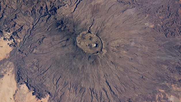


An astronaut aboard the International Space Station (ISS), a member of Expedition 72, recently took a photo of Emi Koussi (Mount Koussi). This massive, extinct volcano, which last erupted about 1.3 million years ago, rises in the heart of the Sahara in northern Chad. Standing at 3,414 metres above sea level and stretching an impressive 69 kilometres, the wide cone of the volcano is crisscrossed with dark lava streams, reminiscent of its fiery past.
There is no trace of snow at the summit
The latest photo was published by NASA Earth Observatory. Emi Koussi, surrounded by sunlit plains of bright desert sand, is the highest point in the Sahara. When we look at the photograph, we see something extraordinary: white layers, but not of snow—of salt. It is the bottom of a salt lake that has settled at the bottom of the caldera, as NASA Earth Observatory reports.

It is certainly a striking contrast to the dark volcanic rock. The dry salt lake is located approximately 744 metres below the summit. Nearby, you can also spot several round volcanic craters, remnants of past eruptions.
Hidden canyons and neighboring volcanoes
Numerous dry riverbeds appear as thin lines on the slopes of the volcano, radiating out from the caldera, describes NASA Earth Observatory. Despite very low rainfall in the region, geologists believe these channels were formed by water erosion that has occurred over thousands of years. Several channels on the lower slopes, including those at the bottom of the image, are marked by shadows.

A line of small, round cones and craters appears on the northern slope of the volcano. It runs towards the slopes of Tarso Ahon, another large volcanic mountain. The depression between Emi Koussi and Tarso Ahon is occupied by deep canyons, which cast the largest shadows. One canyon is 600 metres deep and leads water to the west, while another is 250 metres deep and directs water to the east. The canyons formed in the depression due to the concentration of water runoff from both Emi Koussi and Tarso Ahon.

This photo, designated as ISS072-E-423041 and published by NASA Earth Observatory just now, was taken by an astronaut aboard the International Space Station on December 29, 2024, using a Nikon Z9 digital camera with a 200 mm lens. It was captured during Expedition 72 and comes from the ISS Crew Earth Observations Facility and Earth Science and Remote Sensing Unit at NASA’s Johnson Space Center.


